


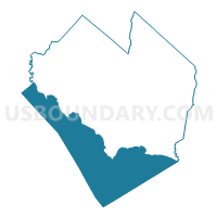
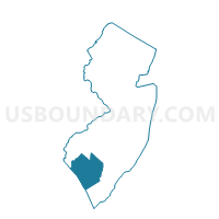
Voting Districts not defined, Cumberland County, New Jersey
About
Outline

Summary
| Unique Area Identifier | 618112 |
| Name | Voting Districts not defined |
| County | Cumberland County |
| State | New Jersey |
| Area (square miles) | 173.14 |
| Land Area (square miles) | 0.00 |
| Water Area (square miles) | 173.14 |
| % of Land Area | 0.00 |
| % of Water Area | 100.00 |
| Latitude of the Internal Point | 39.19730440 |
| Longtitude of the Internal Point | -75.18351110 |
Maps

Graphs
Select a template below for downloading or customizing gragh for Voting Districts not defined, Cumberland County, New Jersey


Neighbors
Neighoring Voting District (by Name) Neighboring Voting District on the Map
- Voting District 05-33, Kent County, DE
- Voting District 06-28, Kent County, DE
- Voting District 07-32, Kent County, DE
- Voting District 08-28, Kent County, DE
- Voting District 13-28, Kent County, DE
- Commercial township voting district 1, Cumberland County, NJ
- Downe township voting district 1, Cumberland County, NJ
- Downe township voting district 2, Cumberland County, NJ
- Fairfield township voting district 3, Cumberland County, NJ
- Greenwich township voting district 1, Cumberland County, NJ
- Lawrence township voting district 1, Cumberland County, NJ
- Lower Alloways Creek township voting district 2, Salem County, NJ
- Maurice River township voting district 2, Cumberland County, NJ
- Voting Districts Not Defined, Cape May County, NJ
Top 10 Neighboring County Subdivision (by Population) Neighboring County Subdivision on the Map
- Dover CCD, Kent County, DE (77,165)
- Smyrna CCD, Kent County, DE (22,978)
- Milford North CCD, Kent County, DE (10,236)
- Maurice River township, Cumberland County, NJ (7,976)
- Fairfield township, Cumberland County, NJ (6,295)
- Commercial township, Cumberland County, NJ (5,178)
- Lawrence township, Cumberland County, NJ (3,290)
- Lower Alloways Creek township, Salem County, NJ (1,770)
- Downe township, Cumberland County, NJ (1,585)
- Greenwich township, Cumberland County, NJ (804)
Top 10 Neighboring Place (by Population) Neighboring Place on the Map
Top 10 Neighboring Elementary School District (by Population) Neighboring Elementary School District on the Map
- Maurice River Township School District, NJ (7,976)
- Fairfield Township School District, NJ (6,295)
- Commercial Township School District, NJ (5,178)
- Lawrence Township School District, NJ (3,290)
- Lower Alloways Creek Township School District, NJ (1,770)
- Downe Township School District, NJ (1,585)
- Greenwich Township School District, NJ (804)
Top 10 Neighboring Secondary School District (by Population) Neighboring Secondary School District on the Map
Top 10 Neighboring Unified School District (by Population) Neighboring Unified School District on the Map
- Capital School District, DE (54,739)
- Caesar Rodney School District, DE (43,649)
- Smyrna School District, DE (33,222)
- Milford School District, DE (27,933)
- School District Not Defined (Water), NJ (0)
Top 10 Neighboring State Legislative District Lower Chamber (by Population) Neighboring State Legislative District Lower Chamber on the Map
- General Assembly District 3, NJ (235,440)
- General Assembly District 1, NJ (217,333)
- State House District 33, DE (24,737)
- State House District 28, DE (22,917)
- State House District 32, DE (20,481)
- State House Districts not defined, NJ (0)
Top 10 Neighboring State Legislative District Upper Chamber (by Population) Neighboring State Legislative District Upper Chamber on the Map
- State Senate District 3, NJ (235,440)
- State Senate District 1, NJ (217,333)
- State Senate District 14, DE (59,548)
- State Senate District 16, DE (50,103)
- State Senate District 17, DE (47,176)
- State Senate Districts not defined, NJ (0)
Top 10 Neighboring 111th Congressional District (by Population) Neighboring 111th Congressional District on the Map
Top 10 Neighboring Census Tract (by Population) Neighboring Census Tract on the Map
- Census Tract 102, Cumberland County, NJ (5,178)
- Census Tract 104.01, Cumberland County, NJ (5,039)
- Census Tract 101.01, Cumberland County, NJ (3,571)
- Census Tract 103.01, Cumberland County, NJ (3,290)
- Census Tract 105, Cumberland County, NJ (2,235)
- Census Tract 206, Cape May County, NJ (2,083)
- Census Tract 222.01, Salem County, NJ (1,770)
- Census Tract 103.02, Cumberland County, NJ (1,585)
- Census Tract 9900, Kent County, DE (0)
- Census Tract 9900, Salem County, NJ (0)
Top 10 Neighboring 5-Digit ZIP Code Tabulation Area (by Population) Neighboring 5-Digit ZIP Code Tabulation Area on the Map
- 08302, NJ (46,872)
- 08079, NJ (10,987)
- 08270, NJ (8,492)
- 08327, NJ (3,070)
- 08314, NJ (2,511)
- 08349, NJ (2,347)
- 08311, NJ (2,057)
- 08345, NJ (805)
- 08323, NJ (804)
- 08324, NJ (526)